The regions other than Annapurna, Everest & Langtang are taken as other trekking areas. These trekking areas have least spoilt trails. The regions or areas are quite popular among hard-core trekkers. Trekking in such remote and unspoile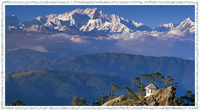 d areas is relatively strenuous but full of adventure and excitement. These regions, considered isolated and less trodden, has abundance of Himalayan peaks, hidden valleys, high passes and sweeping views stretching as far as the arid - Tibetan Plateau. The people living in these regions are mostly of Tibetan origin and have followed Buddhism since time immemorial. Trekking to these regions offer opportunities to visit ancient villages, isolated monasteries and also to experience the vast array of wildlife inhabiting the region including blue sheep, mountain goat, jackal, wolf and the legendary snow leopard. d areas is relatively strenuous but full of adventure and excitement. These regions, considered isolated and less trodden, has abundance of Himalayan peaks, hidden valleys, high passes and sweeping views stretching as far as the arid - Tibetan Plateau. The people living in these regions are mostly of Tibetan origin and have followed Buddhism since time immemorial. Trekking to these regions offer opportunities to visit ancient villages, isolated monasteries and also to experience the vast array of wildlife inhabiting the region including blue sheep, mountain goat, jackal, wolf and the legendary snow leopard.
Dhaulagiri Trek
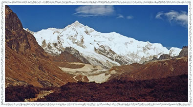
Just west of Annapurna, is the 40 mile wide Dhaulagiri Himal. Dhaulagiri (8167m), the seventh highest peak in the world, towers high above the well-trekked Muktinath pilgrim trail up the Kali Gandaki Valley. The vast massif screens the hidden lands of Dolpo to its north, and to the west of it are Nepal's far western hills. Only to the east, along the Kali Gandaki Valley, we can easily view the mountain close up, so massive Dhaulagiri with its symmetrical peak and four major outlines remain an enigma along much of its perimeter. Like fabulous but restricted Dolpo, the complete month-long trek around Dhaulagiri is only for a handful of trekkers. This is because much of the route traverses difficult, remote country. We start our trek from Beni, after a long day drive from Kathmandu going through nice village in the beginning and later through high and remote area of the glacier and passes, to finally come down to Marpha where we meet the main trail of the Annapurna Circuit or Kali Gandaki. Then, we join this trail and make the trek through Kali Gandaki Valley and trek up to Muktinath, the gateway of Mustang. As this is Nepal's one of the most demanding trek and goes through glacier, French Pass and Thapa Pass, only experienced trekkers should attempt this trek.
Trek Profile:
| Grade |
: Moderate Hard |
| Avg. walking per day |
: 6 Hrs |
| Maximum Altitude |
: 5250m |
| Best Seasons |
: Feb-May, Oct-Nov |
| Type of Trek |
: Camping/Teahouse |
| Starting Point |
: Beni |
| Ending Point |
: Jomsom |
Suggested Itinerary:
Day 01: Arrival at Tribhuvan International Airport, pick-up & transfer to hotel
Day 02: Kathmandu Valley sightseeing
A day trip around the valley, which is rich in Cultural Heritage, consisting of seven sights listed in World Heritage List.
Day 03: Drive to Pokhara
Situated at 200 km west of Kathmandu, Pokhara is a beautiful and clean city with Phewa Lake on the west and stunning view of Annapurna mountain range on the north.
Day 04: Drive to Beni (850m)
A 4 hrs drive through beautiful green valleys offering you good scenery gets you to Beni, which is the district headquarter of Myagdi district and has a police check post where your trekking permits will be examined. Beni is at the confluence of the Myagdi Khola and the Kali Gandaki.
Day 05: Trek to Babichaur (950m)
From Beni, you leave the Kali Gandaki and head west along the north bank of the Myagdi Khola through the village of Beni Mangalghat to Singa and Tatopani (hot-springs). Crossing the bridge, beyond the village to the south bank of the river, the trail makes a half loop before crossing another bridge, near the village of Simalchour, back to the north bank, from where it continues to the village of Babichaur.
Day 06: Trek to Dharapani (1400m)
Strike out along a high, winding path out of Babichaur. The valley widens and terraced hills develop on both sides of the river. The trail is fairly level and you pass the village of Shahashradhara, cross the Duk Khola and walk through fields arriving at Ratorunga. From here, the valley narrows again and the terraces disappear on either side of the river. Continue to the village of Dharapani.
Day 07: Trek to Muri (1850m)
Cross the river and head north to Phedi. As you leave, the trail starts climbing and there will be many switch-backs until you arrive at the ridge. Again the trail climbs steeply to the villages of Muri. Continue your trek to Sibang and Mattim. From here, you continue up an incline to the snout of a ridge, descend to the Gatti Khola and reach Phalai Gaon (1810m). Cross the Dhara Khola, to once again emerge on the west bank of the Myagdi Khola and then climb a ridge to the large Magar village of Muri.
Day 08: Trek to Boghara (2080m)
After a short descend, we cross a stream and continue through terraced fields before climbing a ridge to reach the pass from where you can see Mt. Ghustung South (6465m). Descend to the Myagdi Khola and trek along its west bank to the village of Naura from where you will climb a little before traversing a grassy hill and climb a steep slope with switch-backs and then descend through a forest and terraced fields to Boghara (2080m).
Day 09: Trek to Dobang (2520m)
The trail beyond Boghara descends through terraced fields to a small ridge and then through a forest to Jyardan. After the settlement a high winding path crosses a rocky area and then descends before climbing again to Lipse where there is a single hut. The trail continues through a forest to Lapche Kharka and then climbs to Dobang.
Day 10: Trek to Choriban Khola (3110m)
Crossing a wooden bridge out of Dobang the trail ascends a forested area. Soon the west face of Dhaulagiri I (8167m) becomes visible through breaks in the trees. Descend to the Myagdi Khola and cross it via a wooden bridge to the east bank, continue to Chartare. Passing through forests again, you cut across a rocky area and cross a stream to Choriban Khola.
Day 11: Trek to Italian Base Camp (3660m)
Follow a trail (which is not very well defined) to the terminal moraine of the Chhonbarban Glacier and enter the glacier from the right. Tukche Peak (6837m) becomes visible straight on at the far end, while the impressive north flank of Dhaulagiri I (8167m) dominates the skyline to your right. After a short while you will reach the Italian Base Camp (3660m), which is also the site of your camp for the night. To the west, there are the peaks of Dhaulagiri II (7751m), Dhaulagiri III (7715m) and Dhaulagiri V (7618m).
Day 12: Rest day
Rest day for acclimatization
Day 13: Trek to Glacier Camp (4210m)
Set off early in the morning when the weather is clearer. Today we stay overnight near a glacier.
Day 14: Trek to Dhaulagiri Base Camp (4740m)
Tukche Peak (6837m) becomes visible straight on at the far end, while the impressive north flank of Dhaulagiri I (8167m) dominates the skyline to your right. After a short while you will reach Dhaulagiri Base Camp (3660m), which is also the site of your camp for the night. To the west, there are the peaks of Dhaulagiri II (7751m), Dhaulagiri III (7715m) and Dhaulagiri V (7618m).
Day 15: Rest day
Another rest day
Day 16: Trek to French Pass (5100m) – Hidden Valley High Camp (4915m)
After the glacier, you climb two terraced hills before entering a valley. Climb to the French Pass (5100m) from where you can see Mukut Himal (6328m), Tashi Kang (6386m) and Sita Chuchura (6611m). To the south is Tukche Peak and beyond is the massive peak of Dhaulagiri I. From the French Pass, you continue along the right edge of the hidden valley to Thapa Pass (5250m). Descending from the Thapa Pass you will make a high camp at about 4915m.
Day 17: Cross Dhampus Pass (5170m) & trek through Yak Kharka (3680m)
Descend from the high camp, to the Dhampus Pass and continue to Yak Kharka. There is a perfect camp site to enjoy the surrounding.
Day 18: Trek to Marpha (2667m) & continue to Jomsom (2710m)
Descend to the village of Marpha, on the west bank of the Kali Gandaki River. Continue to north, up the river valley to the town of Jomsom.
Day 19: Fly to Pokhara
Enjoy the attractions of Pokhara.
Day 20: Drive/fly back to Kathmandu
Arrive at Kathmandu and celebrate your successful trek of the Dhaulagiri massif.
Day 21: Departure or free for personal activities
Dolpo Trek
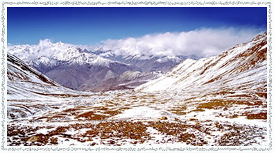
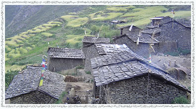
Dolpo is a Tibetan-like region situated to the north and in the rain-shadow of the main Himalayan peaks. Like Mustang, it has a unique culture. Its people wear traditional Tibetan-style clothes and jewelry and practice the pre-Buddhist animistic religion of Bon Po. Its remoteness and the fact that until recently it was strictly off-limits, has meant that the traditions and way of life have remained intact.
The trail passes many gigantic mountain ranges - Annapurna, Dhaulagiri and Kanjirowa, to name a few – and through Lower Dolpo, at one time a small kingdom in its own right. Most villages in Dolpo are removed from the rest of the world to the south by one or more difficult passes. The people that live here number only a few hundred and are among the world's highest dwellers. The villages in Upper Dolpo are 4300m and above.
Trek Profile:
| Grade |
: Moderate Hard |
| Avg. walking per day |
: 6 Hrs |
| Maximum Altitude |
: 5150m |
| Best Seasons |
: Feb-May, Oct-Nov |
| Type of Trek |
: Camping |
| Starting Point |
: Jhupal |
| Ending Point |
: Jhupal |
Suggested Itinerary:
Day 01: Arrival at Tribhuvan International Airport, pick-up & transfer to hotel
Day 02: Kathmandu Valley sightseeing
A day trip around the valley, which is rich in Cultural Heritage, consisting of seven sights listed in World Heritage List.
Day 03: Fly to Nepalgunj
The morning will be free to carry on souvenir hunting or sightseeing, and in the afternoon you will take the flight to Nepalgunj. The flight will give good views of the Himalaya to the north. Transfer to your hotel. There will be time in the evening to have a look around the town, which is situated 3 km from the southern Nepal-India border. Here, it is quite hot and tropical.
Day 04: Fly to Jhupal (2400m) & trek to Dunai (2150m)
A wonderful early morning 45-minute flight over the Himalayan foothills, with the major peaks including Annapurna and Dhaulagiri to the north-east, takes you to the airstrip at Jhupal. It takes about an hour to descend through the village below the airstrip. It is a beautiful walk through ridge of hill and passing many villages along the way. You walk through terraced fields to the Bheri River and the narrow gorge, leading in 2 hours, to Dunai. This is a much larger village or small township and is the administrative headquarter of the Dolpo region.
Day 05: Trek to Ankhe (2660m)
From Dunai, you cross the new suspension bridge and turn west, following the trail past the new hospital. At the confluence of the Thuli Bheri and Suli Gad Rivers you turn to the north and follow the Suli Gad. The trail is fairly undulating but mostly up and the going is firm underfoot. You are never far from the river and can always hear its roar. You continue to track the river and eventually reach the settlement of Hanke, which is also the entrance to the Phoksundo National Park. The three villages you pass through have a strange name connection: Parela, meaning eyelash, Rahagaon meaning eyebrow, and Ankhe meaning eye.
Day 06: Trek to Renje (3104m)
The trail undulates to start with, but once you have crossed the river twice on well-made bridges, you then make a steep ascent on a very narrow path hugging the cliff face. Having descended to the river again the trail takes another steep ascent, necessitating frequent stops to admire the scenery, for water and for breathers. Your night stop is located on the opposite side of the Suli Gad River from the village of Renje.
Day 07: Trek to Shey Phoksundo Lake
You continue to track along the river and the going is fairly easy initially. A stop at the National Park Office near Sumdo is well worth a visit. From Sumdo, the trail is severely up. Here you leave the river and follow the path high above the water. You ascend to a ridge, about 3875m, from where you will have the most staggering views of a 300m waterfall, the highest in Nepal, and your first view of Shey Phoksundo Lake, a study in turquoise. You then descend through birch forests to the upper reaches of the Phoksundo Khola and on to the picturesque settlement of Ringmo with its mud plastered Chortens and Mani Walls. From the settlement, it is a short walk to the shores of Phoksundo Lake where you set up camp.
Day 08: Rest day
The nearby Tibetan Buddhist Monastery is well worth a visit, as is the village of Ringmo. A walk around the lake is also very relaxing.
Day 09: Trek to Phoksundo Khola (3507m)
From the lakeside you follow the trail that skirts the edge of the lake itself. This precarious trail is suspended on a gangway of wood, supported by pegs, driven into crevices in the rocks and signals the remoteness of the area you are about to enter. You go very steeply up, to 4040m, and then plunge down again to the valley bottom to enter the flood-plain of the Phoksundo Khola and trek to your night stop alongside the river, but within the confines of the forest to avoid the worst of the wind, which is prevalent in the valley bottom.
Day 10: Trek to Phoksundo Bhanjyang (4402m)
There are quite a few stream crossings today, so you should take sandals or footwear suitable for knee deep crossings. This morning, you continue along the level path through a glacial valley that now heads due north. As this becomes narrower and narrower there are impressive vertical cliffs and contorted rock formations. At the confluence of the Phoksundo Khola and another unnamed mountain stream, there is an old wooden bridge. Here you take the barely discernible path to the north-east up a side valley, which has a cavernous look. There is no trail as such, so it is necessary to clamber over rocks and boulders and to ford a stream that rushes down the steep valley. A long climb brings you to a sheep meadow, where the trail veers up a steep ravine. A hard climb to the top brings you to yet another valley, where you can see the Kang La, the pass will lead you to Shey Gompa.
Day 11: Cross the Kang La (4151m) & trek to Shey Gompa (4126m)
After an initial easy stretch going up the flood-plain, the trail goes up very steeply. The somewhat indistinct track is physically demanding, especially on the loose slate scree. It will take about 2.30 to 3 hrs to reach the top of the Kang La (5200m). The views from the top however are magnificent and well worth all the hard work. On descending steeply to the valley floor, not more than 45 minutes, you make a long meandering trek along the banks of the river, crossing it once. A red Chorten heralds your arrival at Shey Gompa, where a quaint wooden log bridge leads up to the Shey compound.
Day 12: Rest day
As Shey means crystal, this monastery is also known as the Crystal Mountain. The Lama of Shey resides at a red hermitage known as Tsakang Gompa, which is west of Shey. It is not really a monastery but a retreat. Tsakang had been a meditation centre of many famous Lamas from Tibet. Shey is famous for its ancient Buddhist culture. In Dolpo, the ancient Tibetan way of life combines animism with the teachings of Buddha. Drutup Yeshe introduced Buddhism in the Dolpo Valley. Many years ago he came to Dolpo and came across wild people, whose supreme god was a 'fierce mountain spirit'. Crystal Mountain is to the west of Shey Monastery. It is a very strange mountain indeed. Its contorted cliffs are laced with quartz and embedded with a rich variety of marine fossils. Shey Gompa stands above the confluence of Kangju Nala and Yeju Nala. Near the confluence, there is a group of prayer mills, turned by water-wheels.
Day 13: Cross the Saldang La (4785m) & trek to Namduna Gaon (4400m)
You start by following a pleasant track amidst juniper, which ascends to a grey, stony canyon. This then begins to zigzag over bare rocks and coarse eroded soil, until it eventually brings you to a flat spot suitable for a brew or lunch if the weather is fine. You then continue very steeply up for 20 minutes before traversing to the top of the Saldang La. Here you can enjoy great views towards the arid landscapes of Mustang and the distant snow peaks of Tibet.
The subsequent descent towards the north is long and tiring, but you finally come upon the welcome sight of pastures of grazing yaks and sheep and nomadic tents made of yak hair. This signals your approach to Namduna Gaon. Namgung Monastery, a red stone structure, is built against the backdrop of a cliff on the north wall of a gorge. The red and white colours of the Gompa and its Stupas are the only colour in this stark landscape.
Day 14: Trek to Saldang (3903m)
In the morning after packing up the loads, you leave the Namgung Monastery and start climbing a scree slope. Further on begins a long thrilling traverse along some dusty barren mountains. Looking down into the valley bottom, it is very evident that the people have made best use of the fertile valley as one sees the neat terraced fields showing bright patches of green and ripening crops. You ascend to 4705m before going down steep slopes to the picturesque village of Saldang, situated on a plateau high above the Nam Khong Nala and the biggest village of the inner Dolpo area. Though the village lies at about the same altitude as Ringmo, it is totally different. Ringmo, a Himalayan village, is situated below the tree line, while Saldang belongs to the arid zone of the trans-Himalayan Tibetan plateau. The village stretches for 2 km on an open slope and consists of 5 villages having 80 well-built houses with nearly 600 hundred villagers. It is prosperous, not only agriculturally, but also for its strategic location on a trade route to Tibet.
Day 15: Rest day
Today is free for relaxation and mixing with the villagers in Saldang. It may be possible to visit the aid post and speak with the Tibetan doctors about their treatments and medicinal herbs, which are traded back and forth between Saldang and Kathmandu. You can also visit the new Gompa, which was painted by Tiley, the gentleman who played one of the leads in the film ‘Himalaya’.
Day 16: Trek to Sibu (3942m)
You bid farewell to Saldang and on the way down to the river-bed you pass through terraced fields, Stupas, Chortens, heaps of Mani stones and a Chaiba Monastery. Namdo, the next village, stretches for more than 5 km on the high slopes to the left of Nam Khong Khola. The Namdo Monastery is located near the river-bed. There is also another monastery on top of a high cliff. You camp near the small settlement of Sibu, right on the river bank.
Day 17: Trek to foot of the Jeng La (4369m)
Following the line of the river valley the trail is fairly easy going initially. After about 2 hrs, it is necessary to wade another stream before turning into a side valley and the rise becomes very sharp. After only 4 hrs walking, you reach to the foot of Jeng La. This is a pleasant meadow, but bestrewn with rocks, yak and other animal droppings.
Day 18: Cross the Jeng La (4845m) & trek to Tokyu Gaon (4240m)
It is only a 2 hrs climb to reach the top of the Jeng La. The trail is generally well compact, making the going underfoot easy, much easier than loose shale, but it is steep. From the top of the pass, there are good views of the Dhaulagiri massif, glittering in the morning light. A rough track descends towards the Tarap Valley. By the afternoon you find a green valley, which leads you through a pleasant track down towards the Tarap Chu. Tarap is a dream valley with vast plains in high mountains extending 20 km along the river Tarap Chu. It has 10 villages with cultivated fields, many Gompas and Chortens of both sects. You halt for the night at Tokyu Monastery.
Day 19: Trek to Dho Tarap (4090m)
Before leaving Tokyu, a short visit can be made to the Chaiba Gompa. The trail is broad and well travelled, making the going easy and there is much evidence of work in the fields, where the women will be bringing in the harvest – the men are away bringing down the herds of animals for the forthcoming winter. There are many Mani Walls but some of the Chortens are in a bad state of repair. The ‘French School’ is just outside the village of Dho Tarap, where you have your night stop. Dho is surrounded by an irregular stone wall and consists of 34 houses, divided into 3 clusters and built in a haphazard way. Tarap is inhabited mostly by Magars, who have lived here for generations, but also by a few Tibetans. The inhabitants of this village are both Bon Po and Buddhist (Nyingmapa). In the afternoon a walk up to the Buddhist Gompa is very worthwhile. The Bon Gompa is about half an hour's walk.
Day 20: Trek to Serkam (3630m)
The next 2 days are longish with a choice of several different campsites, so the itinerary can be flexible. Your route follows the course of the Tarap Khola, generally downhill. You go through narrow gorges with the river rushing through. One may see blue sheep, marmots, yaks, sheep and goats and perhaps meet people from Dolpo taking their flocks of sheep and goats to lower pastures for the winter. The afternoon brings more undulations in the path, when it leaves the immediate course of the river. There is evidence of improvements to the trail where parts of the rock have been blasted out. You will also see the first of the modern steel suspension bridges which have been built to facilitate movement of people and animals. The track is very narrow in places.
Day 21: Trek to Khanigaon (2550m)
You continue to walk down the gorge of the Tarap River, at times alongside it and at others, high above, on a narrow trail built out from the steep slopes. The quality of the path varies from broad, smooth and firm to very narrow and crumbly. There are also flights of man made stone staircases which need to be tackled with care - some of the constituent rocks wobble when stepped upon! An exciting day in deep and awe-inspiring gorges.
Day 22: Rest day
A chance to do some washing in the river, to look around and to visit the local Gompa. Inside it appears dirty and dingy, but behind a screen at the back of the Gompa, there are 3 magnificent double life-sized figures.
Day 23: Trek to Tarakot (2281m)
You leave Khanigaon by the new suspension bridge and then walk alongside the river, sometimes going very high before reaching down to the water again. Some of the going is quite demanding and one bridge, said to have been out for 6 years, necessitates crossing on wet stepping-stones. Coming into the broad fertile valley of the Barbung Chu, you walk amongst the various crops of millet, sweet corn, barley, buckwheat, green beans, chillies and marijuana. Tarakot is an old fortress town known by the local people as Dzong, meaning 'fort'. Before the Gorkha dynasty, Tarakot was the capital and had a dzong. The famous Sandul Gompa, which lies 8 km east of Tarakot and at the junction of Barbung Khola and Tarap Chu, stands on a knoll to the south of Bheri River and at one time supervised collections of tolls for the trading caravans traversing an area called Tichu Rong.
Day 24: Trek to Dunai (2052m)
The trail is mostly down and fairly firm underfoot. Walking beside the Bheri River, you use the original path built 20 ft above the river. All too soon you have reached the village of Dunai. You will now have completed the circuit and a celebration party is sure to happen.
Day 25: Trek to Jhupal (2404m)
You now retrace your steps to Jhupal. Initially the way is flat, but the final hour up to your destination seems steeper than you remember on Day 01!
Day 26: Fly back to Kathmandu via Nepalgunj
Early morning flight to Nepalgunj. This is a wonderful 35-minute flight over the Himalayan foothills, with fine views of the main peaks including Annapurna and Dhaulagiri to the north. You then connect with the flight back to Kathmandu.
Day 27: Departure or free for personal activities
Ganesh Himal Trek
The Ganesh Himal is a major group of Himalayan Peaks located between the Langtang and Annapurna ranges. Trekking to this region is ideal for those wanting to escape from the more popular regions like Annapurna & Everest. It is famous for unusual sights of the traditional lifestyle of the people and unspoiled wilderness.
Starting with a scenic drive from Kathmandu to Trisuli Bazaar, the spectacular remote camping trek to Ganesh Himal follows the least flattened trail far from the maddening crowd in the central Himalayan range of Nepal. Walk through the culturally rich unspoiled ethnic villages and dense forest with gorgeous Himalayan flora and fauna on the backdrop of the breathtaking mountain range of Ganesh Himal (7429m), Manaslu (8163m) and Himalchuli (7540m). Finally reaching Gorkha Bazaar, the historically reach place, from where King Prithvi Narayan Shah the Great, founder of modern Nepal, began his campaign to unify the kingdom.
Trek Profile:
| Grade |
: Moderate |
| Avg. walking per day |
: 5 Hrs |
| Maximum Altitude |
: 4630m |
| Best Seasons |
: Feb-May, Oct-Nov |
| Type of Trek |
: Camping |
| Starting Point |
: Trishuli Bazar |
| Ending Point |
: Gorkha Bazar |
Suggested Itinerary:
Day 01: Arrival at Tribhuvan International Airport, pick-up & transfer to hotel
Day 02: Kathmandu Valley sightseeing
A day trip around the valley, which is rich in Cultural Heritage, consisting of seven sights listed in World Heritage List.
Day 03: Drive to Trisuli Bazaar & trek to Salangkhu Khola
A drive for 4 hrs through beautiful green valleys takes us to Trishuli Bazaar, and then it is 3 hrs walk to Salangkhu Khola.
Day 04: Trek to Balche Village
An easy walk and then a short climb takes us to Kalawale Village. Afterwards, we proceed to the big Tamang Village of Balche (2020m).
Day 05: Trek to Gonga
It’s an easy walk from Balche Village through a forest to Gonga (2800m) and we camp with the peaks of Langtang Lirung and Gosainkunda in good view.
Day 06: Trek to Rupchet
We walk through rhododendron forests this day to Rupchet. Rupchet is a cattle pasture.
Day 07: Rest day in Rupchet
Day 08: Trek to Pangsang
It's a 3 hrs walk up to Singla Pass (4630m), which offers spectacular views of Langtang Lirung, Ganesh Himal, Bouddha Peak, Himalchuli, Machhapuchhre, South Annapurna and Annapurna II. Afterwards, we descend for 2 hrs, following small trails to Pangsang.
Day 09: Trek to Shomthang
Following the ridge of the campsite for 4 hrs, we arrive to Shomthang, from where one can enjoy the close up view of Ganesh Himal.
Day 10: Trek to Jogeshworkunda
A gradual climb for 4 hrs takes us to Jogeshworkunda.
Day11: Rest day in Jogeshworkunda
People interested can do rock and peak climbing above 5000m on this day.
Day 12: Trek to Linju Khola
A gradual descend to Linju Khola.
Day 13: Trek to Serthung Village
We walk down through pine and rhododendron forests to Serthung Village (2050m) and camp with good views of mountains all around. Serthung is a Tamang cultural village.
Day14: Trek to Laba
A short flat trail and then a gradual descent passing through Borang Village followed by crossing the Akhu Khola takes us to Laba, a big Tamang Village.
Day 15: Trek to Mongeythanti
A slight climb to cross a hill and then descent through forests, take us to camp at Mongeythanti.
Day 16: Trek to Dumchet Village
A gradual walk down through forests by a stream brings us to our camp at Dumchet Village.
Day 17: Trek to Budhi Gandaki
We take a gradual walk today to Baseri and camp near the Budhi Gandaki River.
Day 18: Trek to Arughat
We walk along the bank of Budhi Gandaki River and stop at Arughat Bazaar (530m) for the night.
Day 19: Trek to Khanchowk Danda
We gradually climb the Khanchowk Danda crossing the Mukti Khola and camp for the night.
Day 20: Trek to Gorkha
We cross a ridge today and walk gradually uphill to Gorkha, camping near the old palace.
Day 21: Drive back to Kathmandu
We can have a sightseeing tour of Gorkha Palace, the palace of the King Prithvi Narayan Shah, who united Nepal in 1881 AD and visit the Gorkha Bazaar and then drive back to Kathmandu.
Day 22: Departure or free for personal activities
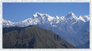
Kanchanjunga Base Camp Trek
‘Kang-chen-zod-nga’, meaning ‘Five Great Treasuries of the Snow’, actually it has seven major summits. To the locals Kanchanjunga, which stands at a height of 8585m (the third highest mountain in the world), is the abode of gods who bestow prosperity and goodwill on them and their lands. To the climbers of this mountain, the phrase ‘Five Great Treasuries of the Snow’ takes on a slightly more ominous tone. The avalanches that Kanchanjunga throws down are said to be the largest anywhere!
 Since the locals worship the mountain, there is a tradition among mountaineers not to stand on the actual summit. All ‘successful’ assaults have stopped just short of the summit honoring an old promise made by the leader of the first successful attempt in 1955 to the Maharaja of Sikkim. Kanchanjunga lies on the eastern border of Nepal providing a great chance to experience the remoteness, spectacular mountain scenery, diverse flora and fauna and rich local culture, quite different to those found in the far-western region of Nepal.
Trek Profile:
| Grade |
: Moderate Hard |
| Avg. walking per day |
: 6 Hrs |
| Maximum Altitude |
: 5400m |
| Best Seasons |
: Feb-May, Oct-Nov |
| Type of Trek |
: Camping |
| Starting Point |
: Suketar |
| Ending Point |
: Suketar |
Suggested Itinerary:
Day 01: Arrival at Tribhuvan International Airport, pick-up & transfer to hotel
Day 02: Kathmandu Valley sightseeing
A day trip around the valley, which is rich in Cultural Heritage, consisting of seven sights listed in World Heritage List.
Day 03: Fly to Taplejung (2320m) & trek to Lali Kharka (2276m)
The flight takes around half an hour to reach Suketar Airport at Taplejung. After landing we take an early lunch, while the crew arranges our gear. In the afternoon, we blow out the cobwebs with an easy 2 to 3 hrs walk along the ridge line to Lali Kharka, a grazing area.
Day 04: Trek to Khesewa (2120m)
After traversing the hillside a short way, we descend to the village of Pakora along the Phawa Khola, crossing a suspension bridge before beginning the steep climb up towards Kunjuri. Lunch will be taken somewhere below Kunjuri and the afternoon's walk takes us to our campsite at Khesewa. We get our first views of Kanchanjunga, and should be able to clearly make out the south and main summit along with Yalung Kang.
Day 05: Trek to Mamankhe (1920m)
Today the path covers steep hillside through terraced fields high above the Kabeli Khola. There are some ups and downs crossing side valleys, but there are many shady spots to rest. After lunch at one of these, we pass the village of Anpan, before descending to cross the Kashawa Khola and then, finally, we climb again through terraced fields to the village of Mamankhe.
Day 06: Trek to Yamphudin (2080m)
Today the walk starts with an easy climb to Yamphudin along a track which contours the hillside above the Kabeli Khola. The path has several ups and downs as we cross the ridges and streambeds that make up the valley sides. Generally the route is flat and the river eventually becomes level with the trail, a couple of hours before Yamphudin. At last we can stop to bathe in one of the clear pools within this beautiful river. It is truly an idyllic spot. After lunch at the river we complete the day's walk to Yamphudin. Yamphudin is the most remote settlement in this area and the last village we will see until we reach Ghunsa. It is a charming place tucked away beneath the ridge of Deurali Danda that we must cross next.
Day 07: Trek to Chitre (2965m)
Beyond Yamphudin the trail ascends a steep spur, a gentle introduction for what will come. Leaving villages behind, we trek through pleasant forest, stopping for lunch in a meadow capturing fine views of the north and south. A steep descend to the river, an interesting bridge across the Omje Khola to our campsite in Chitre.
Day 08: Trek to Tortongn (3010m)
Starting the day with 3 hrs of steep ascent to the crest of the Deurali Danda in dense forest most of the way. From the 3230m Pass, we see Jannu, definitely closer! We descend across some steep and exposed areas before entering the forest again. The sharp descent through beautiful forest continues down into the valley of the Simjua Khola. Across the 'interesting' wooden bridge is Tortongn, a camping place with numerous rock shelters amid towering conifers. The steep hills make today a tough 6 to 7 hrs trekking.
Day 09: Trek to Tseram (3870m)
Today we follow the river through more beautiful forest, the conifers giving way to the rhododendron forest. The valley climbs fairly steep and as the day progresses the trees become more stunted and scattered, giving us glimpses of the snow-capped giants ahead and the massive snout of Yalung Glacier. Just before Tseram, the towering heights of Kabru and Rathong Peak start to peep over the moraine. Camping at Tseram, a grazing area, the night temperatures will remind us that we are really gaining height.
Day 10: Trek to Ramche (4580m)
A short day's walk up the final 600m to Ramche, where the trail to Kanchanjunga South turns dangerous. The scenery is magnificent as we ascend past snout of the Yalung Glaciers into a series of ablation valleys, which gives easy walking and good camping. A frozen lake, clear streams and views of Koktang, Rathong and Kabru are the highlights of this stroll. Expect to feel the altitude today.
Day 11: Explore around Ramche (4580m) & trek to Oktang (4730m)
Our first close encounter with Kanchanjunga. Following the valley round to see the stunning south face of Kanchanjunga and Jannu, we get across the Yalung Ri Glacier and continue by a sweeping curve, at Oktang (4730m), we are suddenly confronted with the southern wall of the mountain. This vast ridge forms a circle over 15 km long, nowhere less than 7500m high and with three main summits of Kanchanjunga at 8420m, 8586m, and 8474m! It is a breathtaking mountain panorama and especially impressive is Jannu while observing the glaciers flowing from its east face.
Day 12: Trek to Yalung Ri Base Camp (5400m)
This extended part will take you to the high altitudes. It requires determination and some luck too. The crossing of high passes requires good weather, and of course perfect logistic support. Expect to get acclimatized with the altitude today.
Day 13: Trek back to Ramche (4580m)
Yalung Glaciers and a series of valleys, give good walking and perfect camping. A frozen lake, clear streams and magnificent views are the highlights of this stroll.
Day 14: Trek to Sallerle over the Mirgin La (4480m)
We trek down the valley, passing the turn, off to the high and challenging Labsang La route to Ghunsa and the north side of Kanchanjunga. This pass is rough and dangerous, especially for porters so we take the more southern set of passes, beginning with the Mirgin La. After an initial steep climb and several false summits we reach Mirgin La. Apart from the magnificent Jannu, on the horizon are Makalu, Gyakung Kang, Everest, Lhotse and Chamalang. To the south it is possible to see down to the Terai, a panorama worth the effort. Our campsite will be beyond the pass, after 6 to 7 hrs tough walking.
Day 15: Trek to Ghunsa (3475m)
Although there are four Passes, there is little descent between them, so in effect it is a high scenic area. After lunch descent brings us to Lamba Sumba Kharka, where there are more views of the awesome south-west face of Jannu. From Kharka the going is easy again down a pleasant forested trail to the village of Ghunsa, where we camp in the village. Ghunsa is a picturesque Tibetan Village; prayer flags flutter from the wooden houses and there are two monasteries, a welcome sight after the many days of wilderness. One of the local specialties’ is 'Tongba', a curious alcoholic drink. A jug or large bamboo cup is filled with fermented millet seed and boiling water poured over. The flavour and alcohol seep though and you drink it with a special straw. You might need a drink after the tough 4 to 6 hr walk.
Day 16: Trek to Kambachen (4040m)
Gradually the trail ascends to south of the Ghunsa Khola and crossing flood-plains while emerging on a pasture situated at the north side of the river. A steep climb to a slope, from where it crosses a slide and then descends to Lakepo. A short climb from here to the village of Kambachen at 4040m.
Day 17: Exploration day
Today we spend acclimatizing to high altitude. It also doubles up as a rest day and can be used for a short morning hike to explore the area around Kambachen. Those who feel the urge should be able to catch up on their laundry. Otherwise, a good book should get you through the day perfectly. It is essential to acclimatize to the higher altitude as you have been spending a lot of time at lower altitudes.
From here, there are good mountain views of the peaks near Kanchanjunga which are visible. You can hike up the ridge above the village for better views or take a day hike to the Jannu Base Camp. The Nepali name for ‘Jannu’ is ‘Kumbhakarna’.
Day 18: Trek to Lhonak (4790m)
A gradual climb through rocky fields gets you to Ramtang at an elevation of 4240m, and then crossing north-west of the Kanchanjunga Glacier you will reach Lhonak. Lohnak is on a sandy plain near a dry lakebed. You will camp between the boulders here to stay out of the wind. There are beautiful mountain vistas all around. Water is very scarce in Lhonak and you will need to use only as much as absolutely necessary.
Day 19: Trek to Pang Pema (5140m)
The main Kanchanjunga Peak is only visible from Pang Pema, which is the Base Camp for expeditions on Kanchanjunga. From Lhonak, the trail gradually ascends across the plain but soon gets steeper as it follows the moraine. Pang Pema is at a height of 5140 m.
Day 20: Explore around Kanchanjunga Base Camp (5100m) & retrace your steps to Kambachen
Today, those who would like to take a morning hike up a ridge, north of Pang Pema, a climb of around 300m, provides a great vantage point with views of Kanchanjunga, Wedge Peak, the Twins and Tent Peak. As usual the descent goes faster and you can reach Kambachen the same day.
Day 21: Trek to Ghunsa
More descents through magnificent sections of forest, it doesn't matter where we stay. From Ghunsa, an hour down we pass through Phole, a village in two parts. The upper sections houses Tibetan refugees, who are well established, the second is the winter village of Ghunsa. Further down is Yangswa, a great and warm camp.
Day 22: Trek to Amjilosa (2460m)
Initially we pass through beautiful forest opening out to steep, grassy hillsides where Amjilosa is perched.
Day 23: Trek to Sakathum (1600m)
Down, down and down! After a short climb we begin the steep descent that will take most of the day. We reach the joining of the Tamur and Ghunsa Kholas.
Day 24: Trek to Chhiruwa (1200m)
We cross the Simjua Khola, which originates from Kanchanjunga's South Base Camp, the Khola that we followed up from Tortongn. It is pleasantly warm at these low altitudes and cardamom grows freely in the moist shaded forest. Crossing numerous small tributary streams we reach Chhiruwa, a village set among large boulders. We camp in a field out of the village. This is an easier day.
Day 25: Trek to Suketar (2420m)
Traversing in an out of minor valleys, we pass through a succession of picturesque villages on our way to Suketar, reaching around late afternoon.
Day 26: Fly back to Kathmandu
Enjoying your last glimpse of the mountains you have recently visited, one last time, on the 35 minutes scenic flight back to Kathmandu.
Day 27: Departure or free for personal activities
Makalu Trek
Barun Valley is located in the eastern part of Nepal offering impressing natural scenery. The main focus point of this trek is Makalu Barun National Park and Conservation Area, which lies in the Solukhumbhu and Sankhuwasabha district, established in 1992 and formally inaugurated in 1992. Mt. Makalu (8463m), the world’s fifth highest peak, Chamlang Himal and Barun Valley are the major jewels of this area.
Having a wide range of altitudinal and climatic variations, the Makalu Barun Area offers a remarkable and diverse habitat of a rich variety of flora and fauna. Plants of all major ecological zones: tropical, sub-tropical, temperate, alpine and sub-alpine are found here. The park is also the home to a rich variety of wildlife.
The highlights of this rich natural paradise include beautiful mountains, pristine forest, and a wide variety of plants, animal life and the simple and warm hearted local people with rich and varied customs.
Trek Profile:
| Grade |
: Moderate Hard |
| Avg. walking per day |
: 6 Hrs |
| Maximum Altitude |
: 5400m |
| Best Seasons |
: Feb-May, Oct-Nov |
| Type of Trek |
: Camping |
| Starting Point |
: Tumlingtar |
| Ending Point |
: Tumlingtar |
Suggested Itinerary:
Day 01: Arrival at Tribhuvan International Airport, pick-up & transfer to hotel
Day 02: Kathmandu Valley sightseeing
A day trip around the valley, which is rich in Cultural Heritage, consisting of seven sights listed in World Heritage List.
Day 03: Fly to Tumlingtar (940m)
An hour flight, in parallel with the views of five 8000m high peaks: Cho Oyu, Everest, Lhotse, Makalu and Shishapangma.
Day 04: Trek to Khandbari (1020m)
From Tumlingtar, walk to Kumhalgaon and follow the trail that passes to the east. Begin an ascent between the Arun Kosi and Sabha Khola observing the view of the huge Chhamlang massif. At the top of the ascent, you will come to Dhunge Dhara. After walking some times you will get to Khandbari.
Day 05: Trek to Chichila (1840m)
Climbing to Naya Bazaar, after a while you reach Mani Bhanjyang (1100m) and further climb in the bamboo forest along the ridge to Arun Than (1280m), and then transverses across the hillside, still climbing through fields and bamboo groves you will get to Sheka (1350m). Keep climbing to the Tamang village of Bhotebas (1740m), which offers a spectacular view of Chhamlang, Makalu and Jaljale Himal. From Bhotebas, climbing for some while you will reach Chichila.
Day 06: Trek to Num (1500m)
Passing the small settlement of Baisake and Kuwapani (1870m) you will reach Hururu (1970m). The route climbs and then drops down into the deep oak forest before arriving at Mure Village (2000m), inhabited by Sherpas and Rais. Descending on a rocky trail you will reach Num.
Day 07: Trek to Sedua (1540m)
The trail descends steeply through the fields of Lumbang and from here the trail becomes steeper through jungle to a suspension bridge over the Arun Kosi. From the bridge the trails climb to Sedua.
Day 08: Trek to Tashigaon (2190)
The trail climbs and then passes the National Park Forest Project and reaches Manigaon. From Manigaon, the trail turns west and makes a gradual climb to Chyaksadanda and to Ropesa. The route crosses meadows and several streams before coming to the Sherpa Village of Tashigaon, a large village on the way to Makalu Base Camp.
Day 09: Trek to Khongma (3560m)
Climbing over the ridge and ascending through the forest you will reach Chipla (2520m). The route now becomes steeper and joins the ridge, before reaching Khongma, a flat high altitude meadow.
Day 10: Trek to Mumbuk (3550m)
From Khongma, you climb up all the time having beautiful views of Chhamlang Peak 6 (6739m) and Peak 7 (6105m). The trail climbs over a ridge to Ghungru La (4050m) and descends to a small lake and then climbs steeply up to Shipton La (4216m). Descending to Keke La (4150m) and making a further descend through a forest of firs you will get to Mumbuk.
Day 11: Trek to Yangle Kharka (3600m)
From Mumbuk, the trail descends down steeply and turns westward along the bottom of the Barun Valley, passes a small cave, crosses several streams, and finally the Barun River on a long bridge before reaching Yangle Kharka, a large meadow.
Day 12: Trek to Merek (4570m)
Climbing gently from Yangle Kharka you will pass Nghe Kharka (3750m). Following the Barun Valley you will pass Riphuk Kharka (3930m) and making a short climb you will reach Jhak Kharka (4210m) and the meadow of Yak Kharka (4400m). The trail climbs over a ridge beyond Yak Kharka and ascends alongside a moraine formed by the lower Barun Glacier. From here, you will have an excellent view of Peak 3 (6477m) and Peak 5 (6404m). Finally, you will reach to Merek.
Day 13: Trek to Shersong (4660m)
From Merek, the trail climbs up and you will reach Shersong, where there is a small stone hut. In Shersong, you will find a good campsite in the Yak pasture. You may even get to interact with some of the locals.
Day 14: Day Trip to Makalu Base Camp (5000m)
From Shersong, the trail climbs gradually to a minor pass above Makalu Base Camp. You will have an excellent view of Makalu, Baruntse (7220m), Peak 6 and Peak 7 and the complete panorama of Everest and Lhotse. Return back to Shersong.
Day 15: Trek back to Yangle Kharka
Day 16: Trek back to Mumbuk
Day 17: Trek back to Khongma
Day 18: Trek back to Tashigaon
Day 19: Trek back to Num
Day 20: Trek back to Chichila
Day 21: Trek back to Mani Bhanjyang
Day 22: Trek back to Tumlingtar
Day 23: Fly back to Kathmandu
Day 24: Departure or free for personal activities
Manaslu Trek
Trekking around Manaslu offers a unique opportunity to experience relatively untouched region of Nepal. Opened for trekking only since 1991, it provides spectacular beauty along the border of Nepal and China and is now a controlled trekking route which allows organized trekking groups with special permits to venture round its spectacular circuit. Located in west-central Nepal, the 177 km trek around Manaslu provides strong walkers the best that Nepal has to offer - fantastic mountain scenery, spanning altitudes from 375m to 5300m, a diverse range of ecosystems and ethnic cultures and a trail that puts one physically closer to Tibet than any other trek in Nepal.
Trek Profile:
| Grade |
: Moderate Hard |
| Avg. walking per day |
: 6 Hrs |
| Maximum Altitude |
: 5213m |
| Best Seasons |
: Feb-May, Oct-Nov |
| Type of Trek |
: Camping |
| Starting Point |
: Gorkha Bazar |
| Ending Point |
: Beshishahar |
Suggested Itinerary:
Day 01: Arrival at Tribhuvan International Airport, pick-up & transfer to hotel
Day 02: Kathmandu Valley sightseeing
A day trip around the valley, which is rich in Cultural Heritage, consisting of seven sights listed in World Heritage List.
Day 03: Drive to Gorkha Bazaar
It takes about 5 hrs by bus to reach Gorkha Bazaar. In the afternoon, visit the old palace of Gorkha and temple of Kalika and Gorakhnath.
Day 04: Trek to Khanchowk (950m)
It is a beautiful walk through ridge of hill and passing many villages along the way.
Day 05: Trek to Arughat (530m)
The trail descents continue from Khanchowk all the way to Arughat Bazaar through cultivated lands, terraced hill sides and villages.
Day 06: Trek to Soti Khola (730m)
The path will go along the Budhi Gandaki River all the way to its headwaters. The trail goes across forests populated by monkeys. When you reach wide area of rice paddies you will come to Arkhet. From here, the trail descends and ascends to reach Soti Khola. There is a good swimming hole and a small waterfall just above the trail.
Day 07: Trek to Lapubeshi (880m)
From here, the course will repeat ascents and descents through the forested area.
Day 08: Trek to Tatopani (800m)
From here, traverse the slope that has farm fields and rice paddies. Further ahead, the valley will become wider. The path will go down to the shores of white sand. Trail still descends and ascends to reach Tatopani, where there is a hot-spring.
Day 09: Trek to Jagat (1350m)
Crossing the suspension bridge and passing the forested area following the path looks like it is carved in the rock to reach Dovan. Soon after crossing villages and suspension bridge in Dovan Khola, trail repeating ascents and descents will come to Jagat.
Day 10: Trek to Ekle Bhatti (1620m)
Climbing over a rocky ridge of Salleri, there are good views of Sringi Himal. Passing through the Gurung villages to reach Ekle Bhatti, where there is a h6 influence of Tibetan.
Day 11: Trek to Deng (1860m)
The route enters a steep uninhabited gorge. Trail descends through grassy slopes dotted with pine trees, offering a pleasant walk through bamboo forest to the Deng Khola.
Day 12: Trek to Ghap (2040m)
The path will go down to river shores. Steep cliffs continue to surround the valley. Cross a suspension bridge to reach Lana. The path will become a gentle ascent till Bih. From here on, traverse through the forest to come to farm fields and go through the Khani then you are in Ghap.
Day 13: Trek to Namrung (2660m)
Moving on to the forest and crossing a few times wooden bridge over in Budhi Gandaki, the path will become steeper till Namru Village. At this stage the Tibetan border is only a few kilometers to the north.
Day 14: Trek to Lho (3100m)
After passing through Bengsam Village, Li and Khani you will come to Hinan Khola. Crossing the streams, you will come to Sho Village, from where the views are open for Naike Peak, Manaslu North Peak and Manaslu. Lho has wide farm fields on the gentle mountain flank. It is a large village with many houses and a fine Gompa. The views from here are excellent.
Day 15: Trek to Sama Gompa (3500m)
Soon after the junction, you will cross the stream using the wooden bridge and zigzag up the forested area to reach to Honsanho Gompa, where it has an open view. After crossing Pungen Glacier, valley will become wider. Move on from one Chorten to another to reach Sama, which is surrounded by a large number of Mani stones and Chortens. The Gompa on the top of the hill is very fine and worth visiting.
Day 16: Trek to Larke Rest House (4480m)
The path becomes steeper, crossing the tundra, it winds its way to the foot of the immense Larkya Glacier, which pours from the Manaslu.
Day 17: Trek Larke Pass (5213m) - Bhimthan (4066m)
Keep ascending on the gentle slope towards Cho Danda and to the pass. Glacier Lake can be seen when you reach to the top of Larke La; colorful prayer flags are flapping in the wind. The view to the west is wide open. After crossing the pass, trail descends all the way to Bhimthan.
Day 18: Trek to Tilje (3300m)
The trail gets easier. It starts with a gentle climb through paddy fields towards the small Karcha La Pass and descends through fir tree and rhododendron forests to Tilje.
Day 19: Trek to Syanje (1350m)
The trail continues down hill and steepest gorge of the Marshyangdi River.
Day 20: Trek to Bhulbhule
Trail continues along the bank of Marshyangdi River
Day 21: Trek to Beshishahar & drive to Kathmandu
A 2.30 hrs walk on a relatively flat trek leads you to Beshishahar (the ending point of the trek). From Beshishahar, it’s around 5 hrs drive to Kathmandu.
Day 22: Departure or free for personal activities
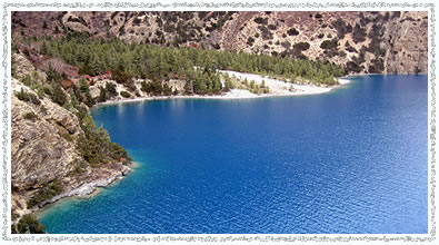
Tilicho Lake Trek
Tilicho Lake, one of the highest lakes in the world, lies in the Annapurna range of the Himalayas in Nepal, at an altitude of 4919m. Stretching about 4 km long and about 1km wide, it lies at the foot of the 7134m summit of the same name, north of the Grand Barrier, a 10 km long wall of rock, ice and snow.
This tarns-Himalayan adventure begins with a spectacular drive from Kathmandu to Beshishahar following the same trail as for Annapurna Circuit Trek up to Manang. Then we leave the lodges on the main trail to head up toward Tilicho Lake. These high Himalayan reaches are the habitat of the Himalayan Thar (Mountain Goat) and the snow leopard, among other mammals. From our camp by the shores of the lake, we climb up to the Mesokanto La (5099m), where we are rewarded with the first views of the Kali Gandaki Valley. We descend to stay at the charming Thakali Village of Marpha. From here, we follow the Kali Gandaki upstream to Kagbeni and up a side valley to the shrine at Muktinath, sacred to Hindu and Buddhist pilgrims alike. The trip ends in Jomsom with an early morning flight to Pokhara.
This is a splendid summer trek, as rewarding as it is challenging. The Tilicho Lake trek is among the finest serious Nepal treks, best experienced in the monsoon.
Trek Profile:
| Grade |
: Moderate Hard |
| Avg. walking per day |
: 5 Hrs |
| Maximum Altitude |
: 5099m |
| Best Seasons |
: Feb-May, Oct-Nov |
| Type of Trek |
: Camping/Teahouse |
| Starting Point |
: Humde |
| Ending Point |
: Jomsom |
Suggested Itinerary:
Day 01: Arrival at Tribhuvan International Airport, pick-up & transfer to hotel
Day 02: Kathmandu Valley sightseeing
A day trip around the valley, which is rich in Cultural Heritage, consisting of seven sights listed in World Heritage List.
Day 03: Drive to Beshishahar & walk to Bhulbhule (910m)
Approximately 5 hrs spectacular drive through beautiful green mountains following Trishuli and Marshyangdi Rivers; one can enjoy the views of Langtang, Ganesh and Manaslu mountain ranges. From Beshishahar, it is a 2.30 hrs easy walk to Bhulbhule following Marshyangdi River.
Day 04: Trek to Jagat (1340m)
Approximately 7 hrs walk through the beautiful green valley passing through some nice villages, crossing several suspension bridges and passing beautiful waterfalls.
Day 05: Trek to Dharapani (1940m)
A relatively tough day including several ups and downs, some of them being very steep. After entering Manang district from Taal, the trail follows the narrow valley up to Dharapani.
Day 06: Trek to Chame (2710m)
The trail now leads to the west from Manaslu passing through beautiful pine forest; a spectacular view of Manaslu mountain range to the east, and Annapurna II and Lamjung Himal to the south. Chame, being headquarter of the Manang district, relatively more movement can be noticed.
Day 07: Trek to Pisang (3240m)
The trail follows Marshyangdi River all day for about 5 hrs and passing through narrow and steep gorge and pine forest. Pisang is a small but very ancient village; one can visit a small monastery at the top of the village, from where one can enjoy a stunning view of Annapurna II (7938m).
Day 08: Trek to Manang (3510m)
After a 5 hrs walk through relatively flat trail and broad forested valley, there is a small airstrip and a village of about 200 houses and Barge Monastery, which is the largest in the entire district.
Day 09: Rest day for acclimatization
A necessary rest day for acclimatization and explore Manang. Manang is one of the most beautiful villages on this trek with the entire line of Annapurnas on the south. A short hiking for about 4 hrs leads you to the Ice Lake (4600m), which is normally frozen from December to February, where you will have a stunning view of entire Annapurna mountain range right in front of you, an unforgettable experience of being in the heart of the Himalayas and also it is very important considering acclimatization.
Day 10: Trek to Khangsar (3734m)
A 2.30 hrs relatively easier walk through the rough landscape gets you to a beautiful and ancient village, Khangsar.
Day 11: Trek to Tilicho Base Camp (4130m)
Couple of hrs ascending and couple of hrs walking through the landslide area and there you are at the Tilicho Base Camp, surrounded by the big white mountains. One has to be very careful while walking through the landslide area as the chances of rocks rolling down from above and a very narrow trail makes the trek a bit risky.
Day 12: Trek to Tilicho Lake (4919m) & back to Base Camp
A steep uphill for 2 hrs and an hours walk through relatively flat trail at an altitude of 4900m and there is Tilicho Lake (4919m) right at the foot of Mt. Tilicho (7134m), a stunning scenery of big white mountains towering in front of you, making you forget all the hard work done to get there.
Day 13: Trek to Nama Phu (3510m) via Mesokanto La (5099m)
Finally, it’s the day of Mesokanto La, a tough ascent for 3.00 hrs (at an altitude where every step is an effort) and you are there at Mesokanto La (5099m). Just have a look around!!! A place where people forget to speak, they will just look at those big white mountains standing tall on every side. One can keep on looking around till the freezing cold pushes one to get down. And it’s not an easy task to get down as well; a scary steep trail between huge rocks for couple of hours might prove harder than the ascent that has been done before.
Day 14: Trek to Jomsom (2713m)
5 hrs racing down through the deserted mountains gets you to Jomsom, completely dry and windy but a lovely town in the Kali Gandaki Valley, with Mt. Nilgiri North towering on the south.
Day 15: Fly to Pokhara
It’s about 25-minutes flight with spectacular views of Dhaulagiri and Annapurna mountain range.
Day 16: Free day in Pokhara
Day 17: Drive/fly back to Kathmandu
Day 18: Departure or free for personal activities
Upper Mustang (Lo Manthang) Trek
Situated north of the Annapurna Himal on the Tibetan border, Mustang is a rugged mysterious arid and haunting wilderness region set amid a lunar landscape of wind eroded hills and cliffs. A Kingdom within a Kingdom, Mustang's wealth was derived from its position on the Kali Gandaki / Thak Khola trade route to Tibet, the region still retains its own King.
Forbidden to foreigners until 1992, Mustang remains a controlled region, which very few people visit, a deliberate policy of cultural and environmental preservation. Our destination is the exotic walled city of Lo Manthang, the seat of the King. The King’s Palace is surrounded by maze of Gompas and private houses all enshrined within the city boundary walls. Unmolested Mustang is frozen in time; it remains one of the ultimate journeys ever likely to be made in one lifetime. The trek allows us to visit all the major villages on route.
Trek Profile:
| Grade |
: Moderate |
| Avg. walking per day |
: 6 Hrs |
| Maximum Altitude |
: 3950m |
| Best Seasons |
: Feb-May, Oct-Nov |
| Type of Trek |
: Camping |
| Starting Point |
: Jomsom |
| Ending Point |
: Jomsom |
Suggested Itinerary:
Day 01: Arrival at Tribhuvan International Airport, pick-up & transfer to hotel
Day 02: Kathmandu Valley sightseeing
A day trip around the valley, which is rich in Cultural Heritage, consisting of seven sights listed in World Heritage List.
Day 03: Drive to Pokhara
Situated at 200 km west of Kathmandu, Pokhara is a beautiful and clean city with Phewa Lake on the west and stunning view of Annapurna mountain range on the north.
Day 04: Fly to Jomsom (2710m)
Catch an early morning flight to Jomsom that takes you up through the Kali Gandaki Gorge between the towering snow-capped peaks of Dhaulagiri and the Annapurna, rising thousands of feet above. This makes truly one of the world's most spectacular flights!
Day 05: Trek to Kagbeni (2885m)
This is an easy half day of trekking to Kagbeni, along the Kali Gandaki River Valley towards Kagbeni, the gateway to the restricted zone of Mustang. The h6 afternoon winds that blow up the Kali Gandaki will be at your back, so you will want to bring along adequate protection to keep the dust out of your packs and cameras.
Day 06: Trek to Chele (3050m)
From Jomsom to Tangbe, the trail winds along the east river-bank and occasionally ventures out into the rocky riverbed. Be on the lookout for black ammonites, small fossils of coiled sea mollusks that inhabited the Tethys Sea, once covering the Tibetan plateau millions of years before the Himalayas were formed. On the lower side of Tangbe, you will see three elegant Chortens and the remnants of an old abandoned fort. In September, the surrounding apple orchards will provide a bountiful supply of delicious fruit. In the dry season, it is possible to trek this entire route up the river along the sand and gravel of the riverbed.
Day 07: Trek to Geling (3600m)
The climb from Chele is up a steep spur to a cairn at 3130m. Here, there is a view of the village of Gyagar across a huge canyon. A long wall of packed earth encircles Gyagar and its field. Your climb continues along the side of the spectacular steep canyon to a pass and cairn of rocks at 3540m. Here, the trail makes a long gradual descent to some Chortens on a ridge, then descends further on a pleasant trail to Samer. Climb above Samer to a ridge, descending into a large gorge, past Chortens painted in red, black, yellow and white. Along the way, the Annapurna Himal is still visible far to the south. From here, you will descend to Geling with its extensive field of barley at 3600m.
Day 08: Trek to Charang (3500m)
From Geling, the trail climbs gently through fields up to the center of the valley, passing below the settlement of Tama Gaon and an imposing Chortens. It rejoins the direct trail becoming an unrelenting climb across the head of the valley to the Nyi La pass at 3950m, the highest point reached on the trek. Charang is a maze of fields, willow trees and houses separated by stone walls at the top of the large Charang Cho Canyon. The huge five-storied white Dzong and red Gompa are perched on the edge of the Kali Gandaki Gorge on the east end of the valley. Near the Gompa is the house of Maya Bista, which, if you have the nerve to get past the ferocious mastiff at the door, doubles as a hotel and restaurant. The village has its own electricity system.
Day 09: Trek to Lo Manthang (3800m)
The trail descends about 100m from Charang, crossing the Charang Chu, climbing steeply up a rocky trail to a cairn on a ridge opposite the village at 3580m, entering the Thulung Valley. The trail turns north and climbs gently as the valley climbs to a large isolated Chorten that marks the boundary between Charang and Lo. Still climbing, the trail crosses a stream then becomes a grand wide thoroughfare, travelling across a desert-like landscape painted in every hue of grey and yellow. Finally, from a ridge at 3850m, there is a view of your destination for the night, the walled city of Lo.
Day 10: Lo Manthang
There are four major temples within the city walls of Lo Manthang. Each of these buildings is locked. The villagers feel it is necessary to control access to the temples, so the caretaker and the keys are available only at certain times. Usually after a bit of negotiation you are able to enter one of the Gompas.
Day 11-12: Lo Manthang
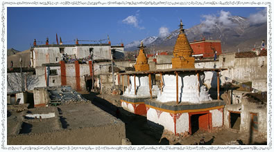
There is a lot to do in Lo Manthang, besides visiting the Gompas. Spend these two days exploring at your own pace. You may want to consider renting a horse to visit some of the other villages in the area. These days will be spent in this mystical and isolated city. You will awake to the mystical sounds of monks chanting and the heady scent of temple candles. You will visit the four major temples within the city walls. The major attraction of this area is the three-storied Jampa Lhakhang, the red Thubchen Gompa with a massive assembly hall, Chodey Gompa and Choprang Gompa.
Day 13: Trek to Ghemi (via Lo Gekar)
You have the opportunity to vary your return route and visit two villages that you did not see on the trek northwards. From Lo Manthang, the trail to Charang heads south. To reach Lo Gekar, you turn east along an indistinct trail that passes the irrigated fields of the city. The trail to Lo Gekar is not a main trading route and the area is crisscrossed with herders' trails, so your local guide is particularly useful here. The trail climbs steadily to a pass marked by cairn, offering a final glimpse of Lo Manthang. The trail contours across the head of the valley, crossing another ridge before dropping into another large desolate valley. After descending to the valley floor, the route heads across two more valleys to an indistinct pass. Cross the pass to some meadows and a stream. The trail then makes a long rocky descent down ravine to a grassy valley where Lo Gekar is situated within a group of large trees nearby a stream. Lo Gekar, which means 'Pure Virtue of Lo', is also known as Ghar Gompa, or ‘House Temple’.
Day 14: Trek to Samar (3700m)
From Ghemi, follow the direct route to Nyi La, climbing to a cairn of a ridge before contouring upwards to meet the trail from Charang. Continue to the pass and descend steeply to the Geling Valley. Follow the trail that bypasses Geling to an isolated teahouse and descend gently to the three houses of Tama Gaon. A steep set of switch backs leads you to a Geling trail near the ridge, just below a Chorten. The remainder of the day is on previously travelled trails back to Samar.
Day 15: Trek to Kagbeni
Retrace the trail upwards, returning to Kali Gandaki and down stream, ending in Kagbeni for your overnight.
Day 16: Trek to Jomsom
Return to Jomsom by way of Kagbeni.
Day 17: Fly to Pokhara
Depart early in the morning (by flight) to Pokhara.
Day 18: Drive/fly back to Kathmandu
Day 19: Departure or free for personal activities
|